LA Cannabis News
The Los Angeles Times has embarked on its own effort to map illegally grown cannabis, one that depended on a view from space.
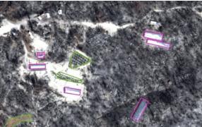
Cannabis operations are easy to spot in satellite imagery. Plastic-covered hoop houses and plots of individual dark-green plants are distinctive and hard to miss, even more so in clear-cut tracts of forest or vast expanses of desert.
The Times obtained 2021 satellite imagery from a mix of public and private sources to canvass nearly 3,000 square miles of land in parts of six counties: Siskiyou, Trinity, Mendocino, Shasta, Butte and San Bernardino.
The analysis counted outdoor cultivation spots and measured the square footage of greenhouses. It avoided areas with other active agriculture that could be mistaken for cannabis, and looked for telltale signs of weed, such as outdoor swimming pools to hold water and outdoor plots adjacent to hoop houses.
To estimate greenhouse crops, The Times used industry-supplied yield formulas. Not all greenhouses were filled and some crops were lost to wildfire or police raids, so The Times followed another industry practice and reduced raw crop estimates by 30%.
Measured that way, the survey area contained 25 million square feet of illicit greenhouses with ample capacity to grow 2.6 million pounds of weed — enough to supply the entire legal California market.
The illegality of these grows was determined using licensing maps obtained from the state Department of Cannabis Control, county permit databases, hemp registrations and tax assessor parcel records. On Native American reservations, where unique ordinances sometimes permit commercial cultivation, The Times also used ownership maps obtained from the U.S. Bureau of Indian Affairs.
By comparing these 2021 maps with those created from satellite imagery four to five years earlier by The Times or by state contractors, the analysis documented dramatic shifts in how and where cannabis is grown.
In every place The Times looked, illicit cannabis production had increased since California reduced criminal penalties for unlicensed operations as part of legalization. There was little variation between areas that licensed cannabis and those that banned it. The findings suggest efforts to draw cannabis growers into the legal market are foundering. All but 68 of the 782 cannabis farms below Post Mountain in Trinity County, for instance, lacked a state license as of early 2022.
Cannabis researchers at UC Berkeley follow a similar methodology to map and measure changes in cannabis cultivation. Humboldt and El Dorado counties also use satellite imagery to find illicit growers and enforce local cannabis codes.
California’s effort to map cannabis began in 2013 after complaints from Butte and other counties that failure to curb illicit operations violated the federal Clean Water Act. The state’s various environmental agencies created marijuana enforcement divisions, and the California Water Resources Control Board in 2015 brought in a private contractor to identify cannabis crops.
The results were outmoded and incomplete. The company reviewed satellite images for only a fraction of California’s geography, steering clear of federal and agricultural lands. Its process was so slow the final maps were two to four years out of date, and the 29,000 “facilities” identified as cannabis grows included not just greenhouses and gardens but also shopping centers.
Read more
Nobody knows how widespread illegal cannabis grows are in California. So L.A. Times mapped them


